• Sectors
    Toggle Dropdown
    • Rail
    • Road
    • Water
    • Land Management
    • Resources
    • Energy
    • Construction
  • Services
    Toggle Dropdown
    • Reality Capture
    • Drone LiDAR Survey & Photogrammetry
    • Survey & Laser Scanning
    • Inspection
    • Geospatial
    • CAD & Revit
  • Technologies
    Toggle Dropdown
    • LiDAR
    • Photogrammetry
    • Laser Scanning
    • Imaging
  • About
    Toggle Dropdown
    • The Diospatial Difference
    • Our Story
  • News & Updates
    Toggle Dropdown
    • Past Projects
    • Blog
  • Contact Us
    Toggle Dropdown
    • Careers
Diodrone
  • Sectors
    Toggle Dropdown
    • Rail
    • Road
    • Water
    • Land Management
    • Resources
    • Energy
    • Construction
  • Services
    Toggle Dropdown
    • Reality Capture
    • Drone LiDAR Survey & Photogrammetry
    • Survey & Laser Scanning
    • Inspection
    • Geospatial
    • CAD & Revit
  • Technologies
    Toggle Dropdown
    • LiDAR
    • Photogrammetry
    • Laser Scanning
    • Imaging
  • About
    Toggle Dropdown
    • The Diospatial Difference
    • Our Story
  • News & Updates
    Toggle Dropdown
    • Past Projects
    • Blog
  • Careers
  • Contact Us

heritage listed

mount-victoria_datasets_5K-Video-e1689129039144-400x300.png

Photogrammetry 3D model bridge
  • Aerial LiDAR & Photogrammetry
  • All
  • Geospatial
  • Inspection
  • Past Projects
  • Photogrammetry
  • Reality Capture
  • Water

Photogrammetry Modelling of a Bridge

March 2, 2023

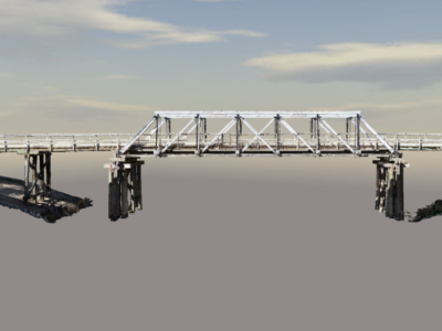
High detail photogrammetry modelling of timber truss bridge for heritage archives. PROJECT…

Read more
Make an Enquiry
© Diospatial 2023
info@diospatial.com.au
  • Linkedin
  • Youtube
Digerati Solutions