3D Survey & Digital twin of Dam & Water Infrastructure
Geospatial Survey of Dam & Infrastructure using Drone LiDAR, photogrammetry, laser scanning and BIM Modelling To support Engineering design.
PROJECT OVERVIEW
Consulting engineers required a geospatial survey of dam and water infrastructure, including the dam, buildings and surrounding terrain to complete a geotechnical assessment, inspection, planning and design of upgrade works. This included a high resolution terrain model of the entire site, photorealistic 3D model for visualisation, and high definition survey of water infrastructure including the pump station.
Due to the large area, hard to access nature of the dam and multiple stakeholder involvement, conventional survey would be inefficient and costly.
Project Scope
Drone LiDAR & Photogrammetry
Terrestrial Laser Scanning
Digital Twin
DIOSPATIAL SOLUTION
Diospatial developed a complete reality capture solution that included a geospatial survey of dam and surrounding areas and utilised the most ideal capture techniques to best achieve the spatial and visualisation needs of the project.
First, a robust network of ground control points were established throughout the site to ensure all spatial data was geo-located and spatially accurate.
A complete spatial solution to inform multiple aspects of the project’s planning, design and construction phases.
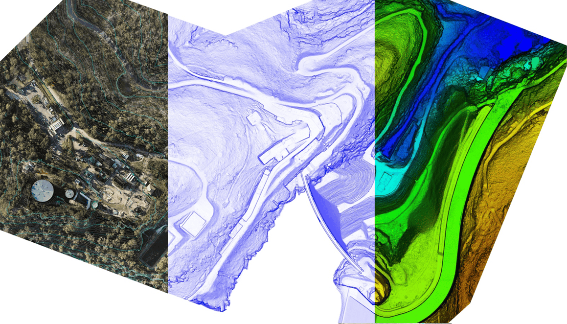
Drone LiDAR was used to create the digital terrain model. The LiDAR was captured at a very high point density to allow for high resolution and accurate terrain modelling, even in areas of vegetation cover. From the LiDAR point cloud, ground and non-ground returns were classified and from this a surface mesh model was produced to show the bare earth terrain beneath vegetation. Elevation contours and rudimentary watershed analysis was extracted from the LiDAR point cloud.
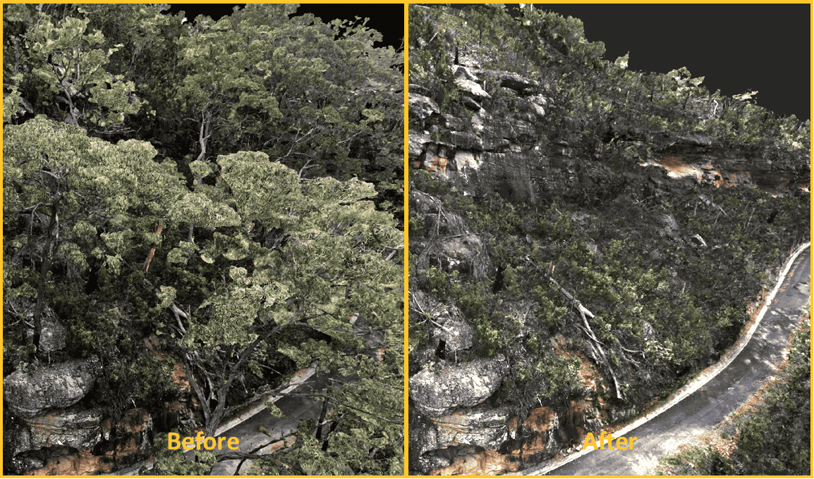
Drone-based imagery was captured and used to create a spatially accurate and rich 3D visualisation of the site. Specific attention was given to the down stream left abutment where imagery was captured underneath the tree canopy. In post-processing, Diospatial data technicians “removed” the tree canopy from the 3D model to allow for inspection and clear visualisation of the terrain beneath.
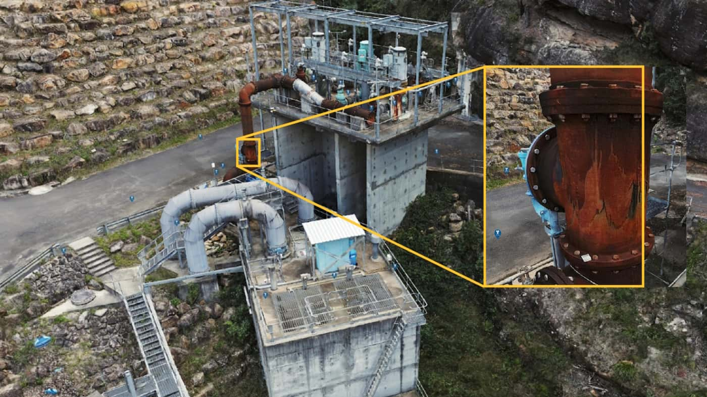
High definition terrestrial laser scanning was completed of the pumping station to produce a high definition, high accuracy point cloud to support detail design of upgrades.
All spatial deliverables were compiled in to a web-based 3D digital twin and hosted via an online portal, Pointerra. This provided project stakeholders with a complete geospatial survey of dam and surrounding areas that could be easily viewed and interrogated via the web-based platform, take measurements and collaborate, without the need for specialist software or powerful computing hardware.