• Services
    • Drone Survey
    • Photogrammetry Modelling
    • Bathymetric survey
    • Laser Scanning & Survey
    • BIM Modelling
    • Geotechnical Survey
    • Dilapidation Survey
    • Inspection
    • Change Detection & Monitoring
    • As-Built Survey
  • Sectors
    • Rail
    • Road
    • Water
    • Land Management
    • Resources
    • Energy
    • Construction
  • About
    • The Diospatial Difference
    • Our Story
    • Our Technologies
    • Capability Statements
    • News
  • Careers
  • Past Projects
  • Contact Us
Diodrone
  • Services
    • Drone Survey
    • Photogrammetry Modelling
    • Bathymetric survey
    • Laser Scanning & Survey
    • BIM Modelling
    • Geotechnical Survey
    • Dilapidation Survey
    • Inspection
    • Change Detection & Monitoring
    • As-Built Survey
  • Sectors
    • Rail
    • Road
    • Water
    • Land Management
    • Resources
    • Energy
    • Construction
  • About
    • The Diospatial Difference
    • Our Story
    • Our Technologies
    • Capability Statements
    • News
  • Careers
  • Past Projects
  • Contact Us

precision aerial survey

Pindari-General-Image-5
  • Water
  • All
  • BIM Modelling - CAD & Revit
  • Dilapidation Survey
  • Drone Survey LiDAR & Photogrammetry
  • Imaging
  • Inspection
  • Photogrammetry
  • Reality Capture

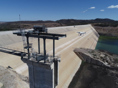
Inspection, Survey and Defect Mapping of Dam using Photogrammetry, Thermal IR and Imaging

October 20, 2020

High resolution inspection and defect mapping over more than 60,000m2 of concrete…

Read more
Make an Enquiry
© 2026 Diospatial.
info@diospatial.com.au
  • Linkedin
  • Youtube