• Services
    • Drone Survey
    • Photogrammetry Modelling
    • Bathymetric survey
    • Laser Scanning & Survey
    • BIM Modelling
    • Geotechnical Survey
    • Dilapidation Survey
    • Inspection
    • Change Detection & Monitoring
    • As-Built Survey
  • Sectors
    • Rail
    • Road
    • Water
    • Land Management
    • Resources
    • Energy
    • Construction
  • About
    • The Diospatial Difference
    • Our Story
    • Our Technologies
    • Capability Statements
    • News
  • Careers
  • Past Projects
  • Contact Us
Diodrone
  • Services
    • Drone Survey
    • Photogrammetry Modelling
    • Bathymetric survey
    • Laser Scanning & Survey
    • BIM Modelling
    • Geotechnical Survey
    • Dilapidation Survey
    • Inspection
    • Change Detection & Monitoring
    • As-Built Survey
  • Sectors
    • Rail
    • Road
    • Water
    • Land Management
    • Resources
    • Energy
    • Construction
  • About
    • The Diospatial Difference
    • Our Story
    • Our Technologies
    • Capability Statements
    • News
  • Careers
  • Past Projects
  • Contact Us

coastal

Image2
  • Geospatial
  • All
  • Construction
  • Drone Survey LiDAR & Photogrammetry
  • Land Management
  • LiDAR
  • Photogrammetry
  • Reality Capture

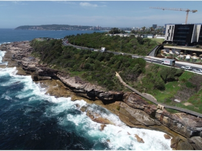
Photogrammetry derived Reality Capture for Boardwalk Design and Geotechnical Assessment

October 20, 2020

High resolution drone LiDAR survey and Photogrammetry modelling for design of elevated…

Read more
Make an Enquiry
© 2025 Diospatial.
info@diospatial.com.au
  • Linkedin
  • Youtube