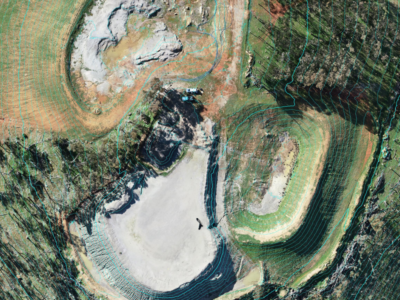
• Services
    • Drone Survey
    • Photogrammetry Modelling
    • Bathymetric survey
    • Laser Scanning & Survey
    • BIM Modelling
    • Geotechnical Survey
    • Dilapidation Survey
    • Inspection
    • Change Detection & Monitoring
    • As-Built Survey
  • Sectors
    • Rail
    • Road
    • Water
    • Land Management
    • Resources
    • Energy
    • Construction
  • About
    • The Diospatial Difference
    • Our Story
    • Our Technologies
    • Capability Statements
    • News
  • Careers
  • Past Projects
  • Contact Us
Diodrone
  • Services
    • Drone Survey
    • Photogrammetry Modelling
    • Bathymetric survey
    • Laser Scanning & Survey
    • BIM Modelling
    • Geotechnical Survey
    • Dilapidation Survey
    • Inspection
    • Change Detection & Monitoring
    • As-Built Survey
  • Sectors
    • Rail
    • Road
    • Water
    • Land Management
    • Resources
    • Energy
    • Construction
  • About
    • The Diospatial Difference
    • Our Story
    • Our Technologies
    • Capability Statements
    • News
  • Careers
  • Past Projects
  • Contact Us

watershed analysis

Hill-End-Ortho-Elevation-Contours_header
  • All
  • Land Management
  • LiDAR
  • Past Projects
  • Photogrammetry
  • Resources

LiDAR Survey of Historic Mining Area

March 15, 2021

Drone-LiDAR Survey to develop a High resolution terrain model of historical mining…

Read more
watershed analysis of rail corridor slopes for monitoring slope drainage
  • Geospatial
  • All
  • Change Detection & Monitoring
  • Geotechnical Survey
  • LiDAR
  • Rail

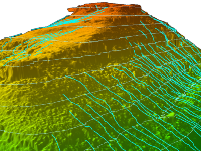
Slope Drainage Monitoring and Watershed Analysis

January 19, 2021

LiDAR and geospatial analysis of rail corridor slopes for inspection and monitoring…

Read more
Make an Enquiry
© 2025 Diospatial.
info@diospatial.com.au
  • Linkedin
  • Youtube