• Services
    • Drone Survey
    • Photogrammetry Modelling
    • Bathymetric survey
    • Laser Scanning & Survey
    • BIM Modelling
    • Geotechnical Survey
    • Dilapidation Survey
    • Inspection
    • Change Detection & Monitoring
    • As-Built Survey
  • Sectors
    • Rail
    • Road
    • Water
    • Land Management
    • Resources
    • Energy
    • Construction
  • About
    • The Diospatial Difference
    • Our Story
    • Our Technologies
    • Capability Statements
    • News
  • Careers
  • Past Projects
  • Contact Us
Diodrone
  • Services
    • Drone Survey
    • Photogrammetry Modelling
    • Bathymetric survey
    • Laser Scanning & Survey
    • BIM Modelling
    • Geotechnical Survey
    • Dilapidation Survey
    • Inspection
    • Change Detection & Monitoring
    • As-Built Survey
  • Sectors
    • Rail
    • Road
    • Water
    • Land Management
    • Resources
    • Energy
    • Construction
  • About
    • The Diospatial Difference
    • Our Story
    • Our Technologies
    • Capability Statements
    • News
  • Careers
  • Past Projects
  • Contact Us

close visual inspection

De-Vegetated Photogrammetry Model
  • Blog

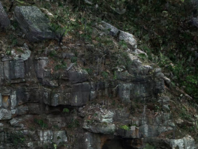
De-vegetated Photogrammetry Model for Geotechnical Inspection

April 19, 2021

It is critically important for geotechnical engineers to complete robust inspections and…

Read more
IMG_Chullora-Warehouse-photogrammetry-model-1
  • All
  • Imaging
  • Inspection
  • Past Projects
  • Photogrammetry
  • Rail
  • Reality Capture

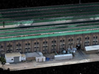
3D Reality Model of Building for Remote Inspection

February 10, 2021

High resolution drone-based imaging and photogrammetry derived 3D reality model of warehouse…

Read more
Make an Enquiry
© 2025 Diospatial.
info@diospatial.com.au
  • Linkedin
  • Youtube